Blue Spatial
Blue Spatial: Geospatial Data Processing and Analytics Software
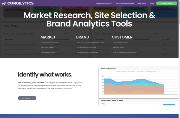
Blue Spatial is a geospatial data processing and analytics software for managing, processing, and analyzing large geospatial datasets. It provides tools for data ingestion, cleansing, visualizing, and transforming spatial data.
What is Blue Spatial?
Blue Spatial is a powerful geospatial data processing and analytics platform designed to handle large and complex geospatial datasets. It provides a complete suite of tools for working with spatial data including:
- Data ingestion from a variety of formats and sources
- Tools for cleansing, transforming, and enriching geospatial data
- Interactive dashboards and geospatial visualizations
- Spatial analysis and modeling capabilities
- Scalable processing of big geospatial data in the cloud
Key capabilities and benefits of Blue Spatial include:
- Handling large volumes of vector and raster geospatial data
- Support for both structured and unstructured data formats
- Interactive dashboards for visual exploration and analysis
- Powerful spatial SQL engine for analysis queries
- Machine learning integration for spatial modeling and predictions
- Flexible deployment options - on-premise or cloud-based
Blue Spatial allows organizations to tap into the power of their geospatial data to drive better decision making and new insights. Its high-performance processing and analytics capabilities make it well-suited for industries like agriculture, transportation, logistics, natural resource management, and smart city initiatives.
Blue Spatial Features
Features
- Data ingestion from various formats and sources
- Data cleansing and transformation
- Spatial analytics and processing
- Interactive visualization and mapping
- Scalable architecture for big geospatial data
- Cloud native implementation
Pricing
- Subscription-Based
- Pay-As-You-Go
- Custom Pricing
Pros
Cons
Official Links
Reviews & Ratings
Login to ReviewThe Best Blue Spatial Alternatives
View all Blue Spatial alternatives with detailed comparison →
Top Ai Tools & Services and Data Analytics and other similar apps like Blue Spatial
Corgilytics