Photo Map vs myPhotoMap

Professional comparison and analysis to help you choose the right software solution for your needs. Compare features, pricing, pros & cons, and make an informed decision.

Photo Map icon
Photo Map
myPhotoMap icon
myPhotoMap

Expert Analysis & Comparison

Struggling to choose between Photo Map and myPhotoMap? Both products offer unique advantages, making it a tough decision.

Photo Map is a Photos & Graphics solution with tags like photo, map, location, geotag, organize, browse, trip, search, filter, explore.

It boasts features such as Map photos based on location using geotag information, Organize and browse photos from past trips, Search, filter, and explore images geographically, Share photos with others, Around 2 million locations mapped and pros including Intuitive and user-friendly interface, Robust features for photo management and exploration, Ability to discover new places through shared photos, Collaborative features for sharing and exploring photos.

On the other hand, myPhotoMap is a Photos & Graphics product tagged with photos, maps, travel, open-source.

Its standout features include Interactive map to map photos from travels, Add images and descriptions to points on the map, Browse locations and zoom in on points of interest, Click on photos to see more details, and it shines with pros like Free and open source, Easy to use interface, Good for mapping vacation/trip photos, Works on mobile and desktop.

To help you make an informed decision, we've compiled a comprehensive comparison of these two products, delving into their features, pros, cons, pricing, and more. Get ready to explore the nuances that set them apart and determine which one is the perfect fit for your requirements.

Why Compare Photo Map and myPhotoMap?

When evaluating Photo Map versus myPhotoMap, both solutions serve different needs within the photos & graphics ecosystem. This comparison helps determine which solution aligns with your specific requirements and technical approach.

Market Position & Industry Recognition

Photo Map and myPhotoMap have established themselves in the photos & graphics market. Key areas include photo, map, location.

Technical Architecture & Implementation

The architectural differences between Photo Map and myPhotoMap significantly impact implementation and maintenance approaches. Related technologies include photo, map, location, geotag.

Integration & Ecosystem

Both solutions integrate with various tools and platforms. Common integration points include photo, map and photos, maps.

Decision Framework

Consider your technical requirements, team expertise, and integration needs when choosing between Photo Map and myPhotoMap. You might also explore photo, map, location for alternative approaches.

Feature Photo Map myPhotoMap
Overall Score N/A N/A
Primary Category Photos & Graphics Photos & Graphics
Target Users Developers, QA Engineers QA Teams, Non-technical Users
Deployment Self-hosted, Cloud Cloud-based, SaaS
Learning Curve Moderate to Steep Easy to Moderate

Product Overview

Photo Map
Photo Map

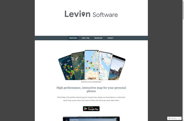
Description: Photo Map is a software that allows users to map, organize and share their photos based on location. It uses geotag information to place images on a map, making it easy to browse photos from past trips. With around 2 million locations mapped, it has robust features to search, filter and explore images geographically.

Type: Open Source Test Automation Framework

Founded: 2011

Primary Use: Mobile app testing automation

Supported Platforms: iOS, Android, Windows

myPhotoMap
myPhotoMap

Description: myPhotoMap is a free, open-source alternative to TravelMap. It allows users to map photos from their travels, creating an interactive map with images and descriptions. Users can browse locations, zoom in on points of interest, and click photos for more details.

Type: Cloud-based Test Automation Platform

Founded: 2015

Primary Use: Web, mobile, and API testing

Supported Platforms: Web, iOS, Android, API

Key Features Comparison

Photo Map
Photo Map Features
  • Map photos based on location using geotag information
  • Organize and browse photos from past trips
  • Search, filter, and explore images geographically
  • Share photos with others
  • Around 2 million locations mapped
myPhotoMap
myPhotoMap Features
  • Interactive map to map photos from travels
  • Add images and descriptions to points on the map
  • Browse locations and zoom in on points of interest
  • Click on photos to see more details

Pros & Cons Analysis

Photo Map
Photo Map
Pros
  • Intuitive and user-friendly interface
  • Robust features for photo management and exploration
  • Ability to discover new places through shared photos
  • Collaborative features for sharing and exploring photos
Cons
  • Limited editing and post-processing capabilities
  • Reliance on accurate geotag data for optimal experience
  • Potential privacy concerns for users who want to keep their location data private
myPhotoMap
myPhotoMap
Pros
  • Free and open source
  • Easy to use interface
  • Good for mapping vacation/trip photos
  • Works on mobile and desktop
Cons
  • Limited customization options
  • No social features
  • Fewer features than paid alternatives
  • Requires manual entry of photo locations

Pricing Comparison

Photo Map
Photo Map
  • Freemium
  • Subscription-Based
myPhotoMap
myPhotoMap
  • Open Source

Get More Information

Ready to Make Your Decision?

Explore more software comparisons and find the perfect solution for your needs