GSMmap is an open-source web server that displays the real-time location of GSM cells and devices on a map interface. It can track cell phones and other devices by interfacing with a compatible GSM modem.
Open-source web server displaying real-time GSM cell locations on a map interface, tracking cell phones and devices via compatible GSM modems.
What is GSMmap?
GSMmap is an open-source web-based geographic information system (GIS) designed to display the real-time location of GSM cells and devices on a map interface. It works by interfacing with a compatible GSM modem connected to the server to obtain location data from nearby mobile devices and cells.
Some key features of GSMmap include:
Real-time tracking of cell phones, vehicles, and other GSM-enabled devices on a map
Display GSM cell tower locations and coverage areas
Web-based interface accessible from any device with a browser
Customizable maps with roads, terrain, and other geographic data
Open-source software with an active development community
GSMmap has uses in areas like fleet tracking, asset monitoring, intelligence gathering, and network analysis. It can provide valuable location insights for businesses, government agencies, and even individual hobbyists. As an open-source platform, GSMmap is customizable and expandable to suit specific tracking and mapping needs.
GSMmap Features
Features
Real-time tracking of GSM devices
Web-based interface to view locations on a map
Open-source codebase
Interface with GSM modems to obtain location data
Pricing
Open Source
Pros
Free and open-source
Allows tracking without needing to install software on devices
Web interface is easy to access
Cons
Requires technical expertise to set up and configure
Limited to tracking GSM devices only
May have legal/ethical concerns around tracking without consent
Android IMSI-Catcher Detector is an open source Android app developed by the AIMSICD team that aims to detect suspicious cell towers known as IMSI-catchers (International Mobile Subscriber Identity-catchers) or stingrays. These fake cell towers attempt to intercept mobile phone communications by tricking phones into connecting to them.The app monitors the...
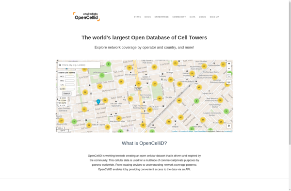
OpenCellID is an open source collaborative project to create a worldwide database of cell tower locations and other related data. It crowd sources data from mobile devices and apps that have OpenCellID SDK integrated to collect information on cell towers in range such as Cell ID, Location Area Code, Mobile...
GSM Spy Finder is a cell phone tracking and monitoring software designed to let you secretly keep tabs on another mobile device without the user knowing. It has a range of spying features including:Monitoring of text messages (SMS) and messages from apps like WhatsApp, Facebook, Snapchat etc.Logging of phone call...
OpenSignal is a free mobile app and website that provides users with information about cellular, Wi-Fi, and other signals in their area. It functions by crowdsourcing data from the devices of users who have installed the app.When OpenSignal is running on a user's phone, it passively collects information about the...
Cell Spy Catcher is an anti-spyware application designed specifically for Android devices. It helps users identify and remove malicious apps, files, or device configurations that could be spying on them.When installed, Cell Spy Catcher will conduct a deep scan of your Android phone or tablet, checking for signs of spyware...
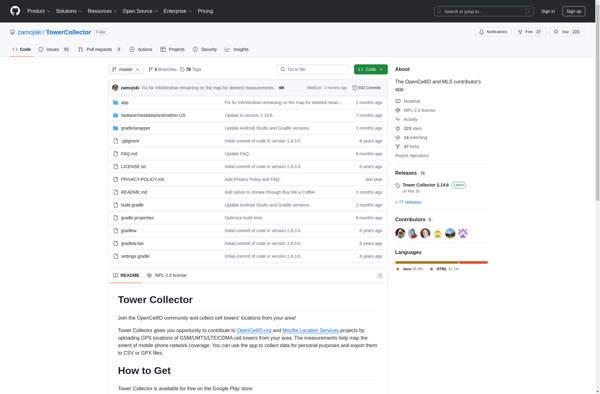
Tower Collector is comic book collection management software for Windows designed to help users organize, catalog, and track their personal comic book collections. It includes extensive database support to store detailed metadata on each comic such as publisher, series, issue number, cover date, writer, penciller, etc.Key features include:Barcode scanning support...
Netmonitor is an open-source network monitoring and analysis tool designed specifically for Linux systems. It provides real-time visibility into network traffic, bandwidth usage, connection tracking, and other critical metrics to help administrators analyze overall network performance.Some key features of Netmonitor include:Capturing traffic from multiple network interfacesIn-depth analysis of bandwidth usage...
openBmap is an open-source, collaborative mapping project with the goal of creating a free and comprehensive map of the entire world. The project relies on volunteer mappers to collect and contribute geographic data which is then made available for anyone to use under an open license.Some key aspects of openBmap...
Cellumap is an open-source software application designed specifically for the analysis and visualization of single-cell spatial transcriptomics data. Single-cell spatial transcriptomics is a novel technique that allows researchers to measure gene expression patterns in individual cells while retaining information about the cells' spatial locations within a tissue sample.Cellumap provides a...
Network Cell Info is a mobile application available for Android and iOS devices that provides users with in-depth details about the cellular network their phone is currently connected to. The app shows the exact location of the cell tower you are connected to on a map, along with the tower...