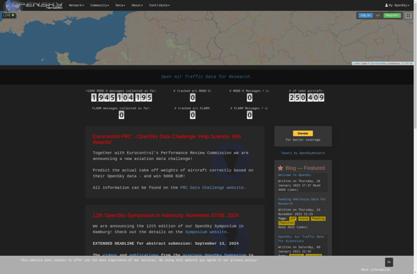
The OpenSky Network is an open-source community of hobbyists, academics, and companies building a large global network of low-cost sensors to monitor aircraft in real-time. The sensors use software-defined radio technology to track aircraft location, altitude, velocity and identi
OpenSky Network: Open-source platform for real-time aircraft tracking
The OpenSky Network is an open-source community of hobbyists, academics, and companies building a large global network of low-cost sensors to monitor aircraft in real-time, using software-defined radio technology to track aircraft location, altitude, velocity and identity.
What is OpenSky Network?
The OpenSky Network is an open-source, crowdsourced community building a large network of sensors across the globe to monitor aircraft traffic in real-time. Volunteers build low-cost ADS-B receivers using software-defined radios like RTL-SDR USB sticks to track aircraft location, altitude, velocity, and identity information.
The open data is used by hobbyists to visualize flight paths, by researchers and academics to study air transportation systems, and by companies to provide enhanced services. Anyone can view location data via OpenSky's live flight tracking web map and access historical data through their free API.
As an open-source project relying on community contributions, OpenSky aims to promote transparency, enable innovation, and increase public knowledge around aviation. With over 2000 sensors across more than 100 countries, the network provides unique global air traffic surveillance independent from government control.
OpenSky Network Features
Features
Crowdsourced network of ADS-B receivers that track aircraft
Open data API and live flight tracking map available
Research platform for collecting and analyzing ADS-B data
Global coverage due to large number of receivers
Ability to build custom applications on top of the data
Pricing
Open Source
Pros
Free access to flight data through API or map
Open source model allows customization and collaboration
Large crowdsourced network provides extensive coverage
Enables new research and applications with ADS-B data
Cons
Data quality dependent on receiver network density
Limited control over receiver network as a crowdsourced system
Mostly hobbyist/academic use, not enterprise-grade performance
Requires technical expertise to fully utilize API and data
FlightRadar24 is a popular flight tracking website and mobile app that provides real-time flight information and aircraft data to the public. The service displays thousands of aircraft around the world on an interactive map, providing insights into airline routes, airports, and more.With FlightRadar24, aviation enthusiasts can track flights in real-time...
ADS-B Exchange is an open-source, volunteer-run platform that collects and shares aircraft location data through crowdsourced ADS-B receivers. It was created to provide improved ADS-B coverage compared to existing flight tracking services by tapping into home-based ADS-B receivers operated by a global network of enthusiasts.The platform aggregates ADS-B data from...
RadarBox is a comprehensive flight tracking and aviation intelligence platform designed for aviation enthusiasts, pilots, journalists, researchers, and businesses. It provides real-time global flight information and data on both commercial and private aircraft.Key features of RadarBox include:Interactive map showing live flight tracks worldwide, with flight details available for each aircraftOver...
FlightAware is a popular flight tracking website and mobile application launched in 2005. It provides real-time data on flight statuses, airport delays, and other information for private, commercial, and cargo flights around the world.Some key features of FlightAware include:Real-time flight tracking - See the current position and status of any...
AirLabs API is a cloud-based artificial intelligence platform that makes it easy for developers to integrate powerful AI capabilities into their applications. It offers a range of AI services via simple REST APIs and SDKs in various programming languages.Some of the key features offered by AirLabs API include:Speech recognition -...
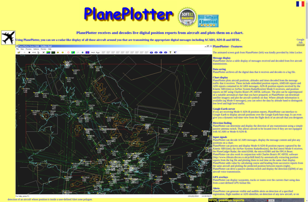
PlanePlotter is a versatile software for tracking aircraft movements and flight data in real-time. It utilizes ADS-B and multilateration (MLAT) data from various receiver sources to plot aircraft positions on interactive maps.Some of the key features of PlanePlotter include:Interactive maps showing live flight tracks, airports, navaids, airspaces etc.Graphs and data...
Plane Finder is an innovative flight tracking software that enables aviation enthusiasts and casual observers alike to identify commercial and private aircraft as they fly overhead in real-time. It works by tapping into the Automatic Dependent Surveillance-Broadcast (ADS-B) and Multilateration (MLAT) systems used by many modern aircraft to broadcast information...
ADSB Hub is an open source, self-hosted web application for aggregating and sharing Automatic Dependent Surveillance-Broadcast (ADS-B) aircraft position data. It allows individuals or organizations to set up their own aircraft tracking feed using one or more ADS-B receivers.Some key features of ADSB Hub include:Aggregates data from multiple ADS-B receivers...