Wardrive is an open-source WiFi mapping and surveying tool for Linux. It allows users to map the locations and details of wireless access points while driving or walking around an area.
Wardrive: Open-Source WiFi Mapping and Surveying Tools
An open-source Linux tool for mapping and surveying wireless access points while driving or walking, providing valuable insights into network coverage.
What is Wardrive?
Wardrive is an open-source application for Linux that is used to map the locations and details of WiFi access points. It allows users to survey an area while driving or walking around with a WiFi-enabled device and GPS, mapping out all the wireless access points that are detected.
Some key features of Wardrive include:
Mapping wireless access points and recording details like SSID, MAC address, encryption type, signal strength, etc.
Integrated GPS support to map locations of access points
Support for external GPS devices via Bluetooth or serial connection
Visual mapping of survey route and locations of detected access points
Export survey data to various formats like KML, CSV, OpenStreetMap XML
Command line and GUI modes
Open source software licensed under GPLv2
Wardrive can be useful for network administrators who want to survey an outdoor area before deploying wireless gear. It can also be used by security researchers and enthusiasts who are interested in mapping out WiFi networks around neighborhoods or cities. The survey data allows analysis of wireless coverage for planning purposes.
Wardrive Features
Features
Scans for WiFi networks in range
Records GPS coordinates of access points
Generates map of WiFi networks based on GPS data
Open source codebase
Available on Linux platforms
Pricing
Open Source
Free
Pros
Free and open source
Allows mapping of WiFi networks in an area
Useful for network surveying and security assessments
NetStumbler is a wireless network scanner application originally released in 2001 for Windows. It is used to detect wireless networks and access points, view and record signal strength, identify network names (SSIDs), determine if encryption is enabled, and generally survey the wireless landscape in an area.Some key features of NetStumbler...
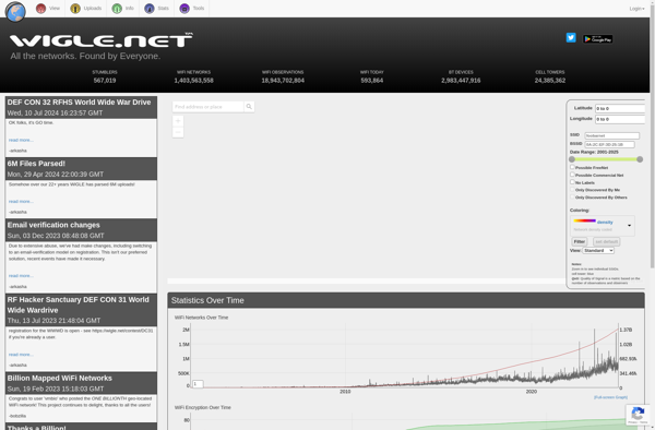
WiGLE (Wireless Geographic Logging Engine) is an open-source web application and API that collects information about wireless networks around the world and maps their geographic locations. It was created in 2001 and relies on a community of users to perform Wi-Fi scans using apps or hardware and submit data about...
WeFi is a cloud-based WiFi analytics platform designed to help businesses optimize their WiFi networks. It provides detailed visibility into WiFi performance, usage, and quality by continuously monitoring key metrics.With WeFi, businesses can track metrics like throughput, client count, connection quality, capacity utilization across access points. It generates heatmaps showing...
WiFi Radar Pro is a feature-rich wireless network scanner, analyzer, and troubleshooting tool for Mac. It provides users with visibility into all the WiFi networks and devices in range, helping diagnose connectivity problems, optimize WiFi performance, and enhance security.Key features of WiFi Radar Pro include:Network scanning to detect all nearby...
RottenWifi is a free mobile app available for both iOS and Android that helps users identify insecure, unencrypted, or otherwise vulnerable public WiFi networks before connecting to them. It actively scans for nearby WiFi networks and analyzes them for potential risks or threats.Specifically, RottenWifi flags networks that are open/unencrypted, are...
WiFinder is a feature-rich Wi-Fi network scanner and analyzer application for Windows. It provides users with an easy way to get a snapshot view of all Wi-Fi networks in range of their computer.Some of the key features of WiFinder include:Real-time scanning to detect all nearby Wi-Fi networks, including hidden onesDetailed...