In2city is map and trip planning software focused on public transit and walking directions. It provides detailed transit schedules, maps, and routing to help users navigate cities using sustainable transportation.
In2city: Map & Trip Planning for Public Transit and Walking Directions
Public transit and walking directions map software for navigating cities sustainably, with detailed transit schedules and routing tools.
What is In2city?
In2city is an urban mobility application designed to promote greener and healthier transportation options for getting around cities. At its core, In2city offers detailed mapping, routing, and trip planning focused specifically on public transportation and walking.
The software provides users with schedules, routes, and live arrival predictions for buses, trains, subways, and other forms of public transit in covered metro areas. This data allows riders to efficiently plan multi-modal trips combining walking and one or more transit options. In2city prioritizes sustainable mobility over driving directions.
Key features of In2city include:
Detailed public transit schedules and maps for buses, metro, rail, etc.
Point-to-point walking, biking, and public transit trip planning
Real-time transit arrival predictions and service alerts
Fare and pricing information for transit modes
Built-in transit card management and mobile ticketing
Wheelchair accessibility and step-free routing
Bike share and scooter integration for first/last mile connections
Users can track carbon footprint and calories burned for each trip
With its focus on transit, walking, and alternative sustainable transportation, In2city aims to reduce car dependency and promote greener urban mobility.
In2city Features
Features
Provides detailed maps and transit schedules for major cities
Offers point-to-point trip planning with public transit and walking directions
Allows users to customize routes by preferences like fewer transfers, wheelchair accessibility, etc
Integrates real-time transit data for accurate ETAs and service alerts
Works offline for use without an internet connection
Pricing
Freemium
Pros
Comprehensive transit data for many major cities globally
Promotes and simplifies the use of sustainable transportation options
Trip planning considers user preferences and needs
Works offline for reliability when internet is unavailable
Cons
Limited to major cities in North America, Europe, and Australia
No support for biking or rideshare directions
Mobile app lacks some advanced features of web version
Yelp is a website and mobile app that hosts crowdsourced reviews about local businesses. It allows users to search for and find information about businesses such as restaurants, shopping, nightlife, services and more. Users can read and write reviews that detail their experiences at those businesses, give star ratings, upload...
Yellow Pages is an online and print business directory that has been around since the 1900s. It allows users to search for local businesses by category, name, or location. Listings generally include basic contact information such as business name, address, phone number, website, and hours of operation.In the past, Yellow...
Loc8NearMe is a location-based mobile app and platform designed to help local businesses connect with potential customers nearby. The app allows users to view promotions, events, menus and more from businesses when they are within a certain radius of the business location.For businesses, Loc8NearMe provides a platform to easily create...
Urbanspoon is a popular restaurant recommendation and reservation platform available as both a mobile app and website. It uses patented algorithms to provide diners with personalized recommendations from its database of over 1 million restaurants across thousands of North American cities and internationally.Key features of Urbanspoon include:Personalized recommendations based on...
Foodspotting is a mobile app and website that helps people find and share the tastiest dishes at restaurants. It takes the concept of traditional user reviews and recommendations and focuses everything around specific dishes instead of just the restaurant as a whole.Users can post photos of standout dishes they love,...
Flamp is a free and open-source, cross-platform desktop publishing software alternative to Microsoft Publisher. With Flamp, users can create various print-ready materials such as flyers, brochures, newsletters, posters, menus, logos, business cards, letterheads and more.It comes with a wide range of page layout tools and options for margins, columns, gutters,...
SiteJabber is an online review platform launched in 2008 that focuses on collecting consumer reviews of businesses in a wide range of industries. The website allows customers to leave detailed reviews and star ratings to share their experiences, both positive and negative, after purchasing products or services from an online...
Apartment Therapy Marketplace is an ecommerce website that offers a curated selection of furniture, home decor, and lifestyle products from small businesses and independent designers from around the world. It is operated by Apartment Therapy Media, which also runs the popular home and lifestyle website Apartment Therapy.The Marketplace features over...
TrustLink is a software that specializes in managing customer reviews and testimonials for businesses. It allows companies to easily collect reviews from customers via invitation emails, review widgets on their website, and integrations with POS systems. Once reviews are collected, TrustLink organizes them into a dashboard that offers analytics on...
Localmint is an open-source web-based accounting software designed for small businesses and freelancers. Here is an overview of its key features and capabilities:- Invoicing - Create professional invoices, enable online payments, track payments owed to you. Automatically calculate taxes.- Expense tracking - Track business expenses. Categorize expenses. Attach receipts and...
Trustoria is an all-in-one online reputation management platform designed for small and medium-sized businesses. It allows companies to monitor customer reviews across the web, engage with customers, generate positive reviews, and analyze review data to make business improvements.Key features of Trustoria include:Review monitoring across 100+ sites like Yelp, Google, and...
Citysearch is an online local search and review platform that provides in-depth listings and recommendations for businesses, events, services, and attractions in major metropolitan areas. Founded in 1995, Citysearch helps connect consumers with great local businesses and things to do in their city.Users can search Citysearch to discover restaurants, bars,...
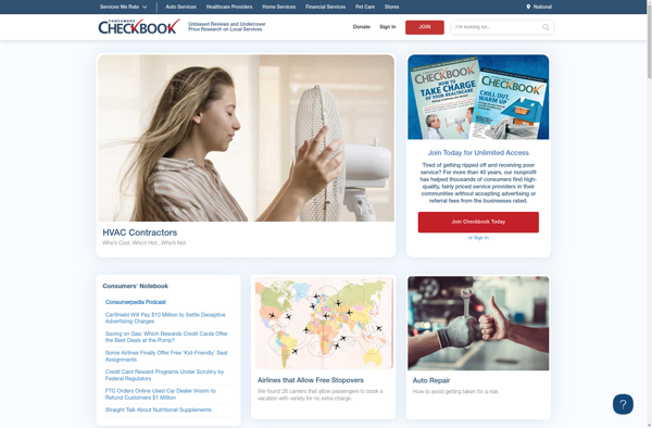
Consumers' Checkbook is an independent, nonprofit consumer organization founded in 1974. For over 45 years, it has been dedicated to helping consumers get the best service and lowest prices.Consumers' Checkbook conducts extensive surveys of consumers' experiences with local service providers in sectors like home improvement, auto repair, health care, and...
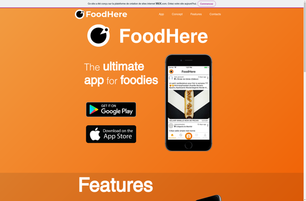
FoodHere is an on-demand food delivery service platform that connects customers with local restaurants. The user-friendly FoodHere app and website allow customers to fully browse menus from partnered restaurants in their area, securely place orders, customize their meals, and arrange for contactless delivery to their home or office.Key features of...
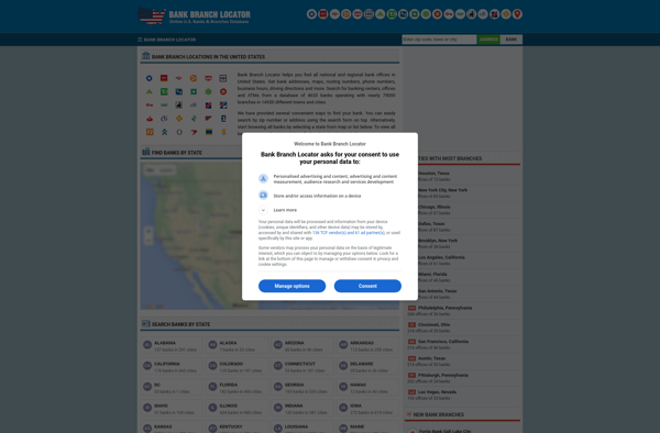
The Bank Branch Locator software is designed to help customers easily find the most convenient branch locations for their banking needs. It is typically offered as a feature on bank websites and mobile apps.Users can enter their zip code, address, or current location into the Branch Locator. It will then...