ZoneSavvy is a cloud-based DNS management platform that allows users to manage their DNS records and settings easily through a intuitive web interface. It provides features like automatic SSL certificate provisioning, geo-routing, and failover.
A cloud-based DNS management platform offering intuitive management of DNS records and settings, with features like SSL certificate provisioning, geo-routing, and failover.
What is ZoneSavvy?
ZoneSavvy is a user-friendly DNS management platform designed to help individuals and businesses easily manage their DNS records and settings without needing expert technical knowledge. It is a cloud-based solution that provides an intuitive graphical interface to add, edit and organize DNS records.
Some key features and benefits of ZoneSavvy include:
Automatic SSL certificate provisioning and renewal - Users can enable free SSL certificates for their domains with a single click.
Intelligent geo-routing - Route website traffic to the closest or fastest responding server to improve site speed for visitors.
Automatic failover - If your primary DNS server goes down, ZoneSavvy instantly switches to the secondary for 100% uptime.
Custom name servers - Use ZoneSavvy's high performance anycast name servers for your domains.
Domain management and DNS record editing - Add domains to your account and easily add records like A, CNAME, MX, TXT etc.
Collaboration tools - Share access to domains and records with other team members.
Custom reporting and alerts - Get notified of expiring SSL certificates, domain renewals and monitor traffic.
API access - Manage DNS programmatically via API.
Overall, ZoneSavvy is designed to make DNS management easy for businesses without needing dedicated infrastructure, personnel or extensive technical expertise. Its user-friendly interface and automation capabilities enable even non-technical users to control their core DNS infrastructure and settings.
ZoneSavvy Features
Features
Cloud-based DNS management
Intuitive web interface
Automatic SSL certificate provisioning
Geo-routing
Failover
Pricing
Subscription-Based
Pros
Easy to use interface
Automates SSL certificate setup
Improves website reliability with failover
Allows targeting visitors by location with geo-routing
Cons
Requires monthly subscription fee
Setup may require some technical knowledge
Lacks some advanced DNS features found in other tools
QGIS is a professional open-source Geographic Information System (GIS) software for working with maps and geospatial data. It is licensed under the GNU Public License. QGIS allows you to view, edit, analyze, process, and visualize spatial data in various formats including shapefiles, GeoTIFFs, PostGIS, SpatiaLite, GPX, and more. It supports...
ArcGIS is a robust and comprehensive geographic information system (GIS) software developed by Esri. It provides a range of capabilities for creating, managing, analyzing, and sharing geospatial data and maps across desktop, mobile, web, and enterprise systems.Key features of ArcGIS include:Advanced geospatial analysis tools for proximity analysis, geocoding, routing, terrain...
SuperGIS is a comprehensive geographic information system (GIS) software developed by SuperMap. It provides a wide range of capabilities for working with maps and geographic data including:Data Capture and Management - SuperGIS can import, manage and analyze spatial data from various sources. It supports vector, raster, CAD, databases, lidar, BIM...
Equator is a cloud-based digital asset management (DAM) and brand management platform used by global companies to easily manage their digital assets. It enables teams to efficiently organize, distribute, collaborate on, and track usage of brand assets from one central place.Key features of Equator include:Cloud-based storage for all digital assetsPowerful...
GRASS GIS (Geographic Resources Analysis Support System) is a free and open source geographic information system (GIS) software suite used for geospatial data management, analysis, graphics and maps production, spatial modeling, and visualization.Some key features of GRASS GIS include:Powerful raster, vector, and geospatial processing tools for analysis and data conversionAbility...
Maptitude is a desktop Geographic Information System (GIS) software developed by Caliper Corporation. It provides tools for creating interactive maps, performing spatial analysis, managing geographic data, and generating reports.Key features of Maptitude include:Interactive mapping - Allows users to create professional-quality maps with layers, labels, scale bars, north arrows, etc.Data visualization...
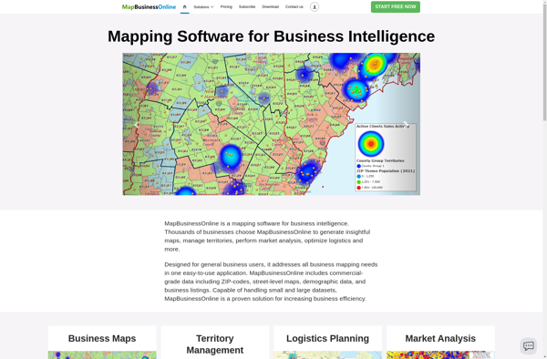
MapBusinessOnline.com is an all-in-one local SEO software designed to help businesses manage their online presence across various directories, maps, and review sites.It allows businesses to:Claim and optimize listings on 50+ sites like Google My Business, Apple Maps, Bing, Facebook, Yelp, YellowPages, Mapquest and more.Update business name, address, phone, website and...
TdhGIS is an open-source geographic information system (GIS) software application developed by Terre des hommes (Tdh), an international NGO focused on humanitarian aid for children. It is designed specifically for public health professionals to map and analyze data to improve programs and policies.Key features of TdhGIS include:Interactive and dynamic mapping...
GeniusGIS is an open-source geographic information system (GIS) software application used for creating, editing, visualizing, analyzing and publishing geospatial data. It provides a user-friendly interface and powerful tools for working with maps and geographic information.Some key features of GeniusGIS include:Interactive map creation and editingAdvanced geospatial analysis and modeling toolsSupport for...