Map Kit Framework is a mapping SDK developed by Apple for embedding maps into iOS, macOS, watchOS, and tvOS apps. It provides tools for displaying map tiles, annotating points of interest, calculating routes and directions, and tracking user location.
Map Kit Framework: Apple Mapping SDK for iOS, macOS, watchOS & tvOS
Map Kit Framework is a mapping SDK developed by Apple for embedding maps into iOS, macOS, watchOS, and tvOS apps. It provides tools for displaying map tiles, annotating points of interest, calculating routes and directions, and tracking user location.
What is Map Kit Framework?
The Map Kit Framework is an iOS and macOS SDK that allows developers to embed interactive maps and location-based services into their applications with ease. Developed by Apple, it integrates tightly with Apple's platforms and devices, providing efficient use of system resources.
Some key capabilities offered by Map Kit include:
Displaying standard, satellite, or hybrid map tile images with overlays like routes and annotations
Accessing the device's GPS and other location sensors to track user movements and current location
Searching for and geocoding point-of-interest locations via Apple's databases
Calculating driving, walking or public transit routes and directions between points
Displaying Points of Interests with details like phone numbers, opening hours and photos
Embedding map objects within scroll and zoom enabled views
Customizing the user interface and interaction behavior of maps
The MapKit API provides a set of classes like MKMapView for displaying maps, MKPointAnnotation for pinning annotations, MKDirections for getting routes & directions between locations, and others. It handles accessing and caching maps efficiently.
MapKit seamlessly integrates with related iOS services like Core Location and Core Data. Combined with features like Launch Screens and Drag & Drop on iPad, MapKit offers a powerful but easy mapping solution for iOS developers.
Map Kit Framework Features
Features
Embedding maps into iOS, macOS, watchOS, and tvOS apps
Displaying map tiles
Annotating points of interest
Calculating routes and directions
Tracking user location
Pricing
Subscription-Based
Pros
Tight integration with Apple's ecosystem
Provides a wide range of mapping features out of the box
Optimized for performance and battery life on Apple devices
Easy to use and well-documented API
Cons
Limited to Apple platforms, not available on other mobile operating systems
Requires an Apple Developer account to use
May have higher costs compared to other mapping SDKs
Mapbox Studio is a powerful desktop application for designing custom map styles. It provides a graphical user interface that allows you to visually style vector tiles created with Mapbox tools and services.Some key features of Mapbox Studio include:Import vector tilesets created with Mapbox tools like Mapbox Streets and SatelliteStyle map...
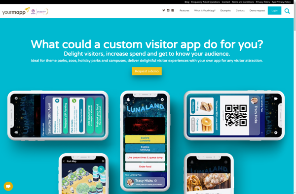
YourMapp is an easy-to-use mind mapping and brainstorming software. It enables individuals and teams to visually organize ideas, concepts, notes, images, documents and internet links in flexible non-linear mind maps.Key features include:Intuitive drag-and-drop interface for quickly creating mind mapsHierarchical trees to organize topics into parent/child relationshipsNotes, links, images and documents...
Mapotic is an open-source, self-hosted alternative to Mapbox that provides developers and designers with tools for creating interactive maps. Some key features of Mapotic include:Ability to design custom base maps with Mapnik and CartoCSSSupport for overlaying vector and raster map tiles from various sourcesTools for visualizing, analyzing, and processing geospatial...
Map3 is a versatile mind mapping and brainstorming software used to visually organize ideas, concepts, notes, and tasks. With Map3, users can create flexible and free-flowing maps to connect thoughts and information.Some key features and capabilities of Map3 include:Tree, org chart, flowchart map views to structure informationTagging and searching maps...
Felt is an open-source web-based application for kanban-style project management and task tracking. It provides a visual interface for organizing tasks into pipelines represented as boards, lists, and cards.Some key features of Felt include:Boards to organize projects and track progress across different stagesCustom lists within each board to categorize tasks...
GeoServer is an open source server for sharing geospatial data. It is the reference implementation of the Open Geospatial Consortium (OGC) Web Feature Service (WFS) and Web Coverage Service (WCS) standards, as well as a high performance certified compliant Web Map Service (WMS). GeoServer forms a core component of the...
Sharemap is an open-source web-based mind mapping and brainstorming application. It allows users to create colorful and visually engaging mind maps to organize ideas, concepts, and information. Some of the key features of Sharemap include:Real-time collaboration - Multiple users can work on the same mind map simultaneouslyRich formatting options -...
The Google Maps API for Business is a paid version of the Google Maps API targeted at business users. It provides additional features and services beyond the free Google Maps API, such as:Custom styling options - Businesses can customize the look and feel of maps to match their brand.Enhanced data...
Mapserver is an open source geographic data rendering engine written in C. It allows users to publish spatial data and build interactive web mapping applications without the need for desktop GIS software. Mapserver excels at rendering spatial data and creating high-performance interactive maps that can be accessed via web browsers.Some...
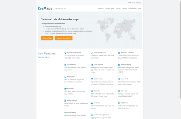
ZeeMaps is an easy-to-use online map creation and sharing application. It allows anyone to create great looking custom maps for free without GIS expertise or design skills.With ZeeMaps, you can add markers, lines, shapes, text notes, images, and videos to your maps to effectively visualize locations, routes, areas and associated...
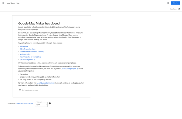
Google Map Maker was a crowdsourced mapping service launched by Google in 2008. It allowed volunteer mappers to edit and update Google Maps with local geographical information and knowledge. The goal of Map Maker was to harness contributions from the public to improve the accuracy, coverage, and freshness of Google...