MICRODEM is an open-source GIS software for analyzing and modeling terrain data. It specializes in geospatial analysis and hydrological modeling for applications like watershed delineation, flow accumulation, landslide assessment, and more.
MICRODEM: Open-Source GIS Software for Terrain Analysis
MICRODEM is an open-source GIS software for analyzing and modeling terrain data. It specializes in geospatial analysis and hydrological modeling for applications like watershed delineation, flow accumulation, landslide assessment, and more.
What is MICRODEM?
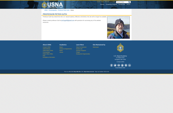
MICRODEM is an open source Geographic Information System (GIS) software application designed specifically for analyzing and modeling terrain data. It was originally developed in the 1990s by Peter Guth of the United States Naval Academy.
Some of the key features and capabilities of MICRODEM include:
Specialized analysis and modeling functions for hydrological, geomorphological, and environmental applications
Watershed delineation and characterization
Flow accumulation and drainage pattern mapping
Landslide susceptibility mapping
Viewshade visualization of terrain
Profiling and sectioning of terrain models
Scripting capabilities for advanced analysis workflows
While more general-purpose GIS software focuses on mapping and visualization, MICRODEM is optimized specifically for specialized geospatial analysis related to terrain, hydrology, soil science, geology, and geomorphology. Its advanced terrain modeling and analysis tools make it well-suited to applications like watershed management, natural hazard assessment, soil erosion modeling, and more.
MICRODEM is commonly used in academic research and teaching in geoscience fields. Its open source license also makes it freely available for any user to download and utilize.
QGIS is a professional open-source Geographic Information System (GIS) software for working with maps and geospatial data. It is licensed under the GNU Public License. QGIS allows you to view, edit, analyze, process, and visualize spatial data in various formats including shapefiles, GeoTIFFs, PostGIS, SpatiaLite, GPX, and more. It supports...
SAGA GIS (System for Automated Geoscientific Analyses) is a free and open source geographic information system (GIS) software used for editing and analyzing spatial data. It contains a large set of geoscientific analysis functions and utilities for managing vector, raster and table data.Some key features of SAGA GIS include:Support for...
what3words is a geocoding system that has divided the world into 3 meter squares and assigned each square a unique 3 word identifier. For example, the square that contains the front door of 10 Downing Street in London has been assigned the 3 word address ///slurs.this.shark.This system allows people to...
Equator is a cloud-based digital asset management (DAM) and brand management platform used by global companies to easily manage their digital assets. It enables teams to efficiently organize, distribute, collaborate on, and track usage of brand assets from one central place.Key features of Equator include:Cloud-based storage for all digital assetsPowerful...
GRASS GIS (Geographic Resources Analysis Support System) is a free and open source geographic information system (GIS) software suite used for geospatial data management, analysis, graphics and maps production, spatial modeling, and visualization.Some key features of GRASS GIS include:Powerful raster, vector, and geospatial processing tools for analysis and data conversionAbility...
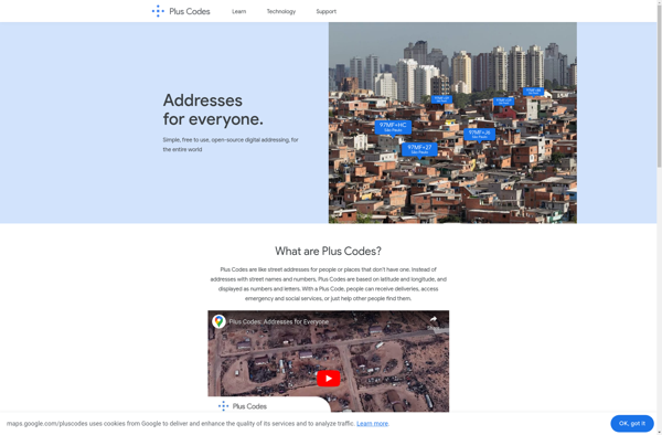
plus.codes is an open-source addressing system developed by Google that assigns a short alphanumeric code to any location on earth. It can be used for addressing and navigation purposes.Some key features of plus.codes:Easy to use, remember and communicate - plus codes are much shorter and simpler than street addressesWorks offline...
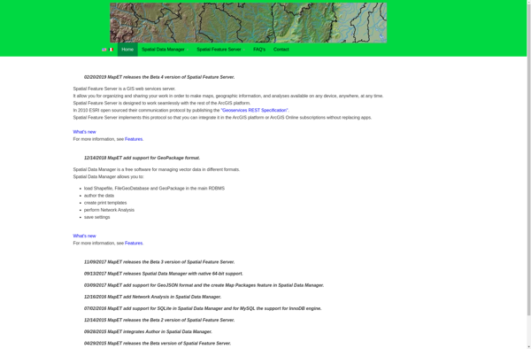
Spatial Feature Server (SFS) is an open-source web mapping software designed for publishing, editing and visualizing spatial data. It is built on open standards like WFS and WMS published by the Open Geospatial Consortium (OGC).Key capabilities and benefits of Spatial Feature Server include:Publishing vector and raster data as web servicesSupport...