CMaps Analytics
CMaps Analytics is a business intelligence and data visualization software that allows users to connect to various data sources, create interactive dashboards and reports, and share insights. It provides self-service BI capabilities for non-technical users.

CMaps Analytics: Business Intelligence & Data Visualization Software
A business intelligence and data visualization software for interactive dashboards, reports, and self-service BI for non-technical users.
What is CMaps Analytics?
CMaps Analytics is a business intelligence and data visualization platform designed to help companies unlock insights from their data. Some key capabilities and benefits include:
- Intuitive drag-and-drop interface to build interactive dashboards and reports without coding
- Connect to various data sources such as SQL, NoSQL databases, cloud apps, etc.
- Perform ad hoc analysis with support for filtering, pivoting, forecasting and more
- Visualize data through charts, graphs, gauges, maps and other graphics
- Pixel perfect reporting for print-ready reports and dashboards
- Collaboration features to share insights across the organizations
- Scheduling and alerts to monitor KPIs
- Role-based access control to manage users and permissions
- On-premise and cloud deployment options available
With its self-service model, CMaps Analytics enables a range of users from business analysts to department heads access data and create their own reports without IT help. It aims to make data more understandable and accessible to drive business decisions across the organization.
CMaps Analytics Features
Features
- Connect to various data sources
- Create interactive dashboards and reports
- Provide self-service BI capabilities for non-technical users
- Share insights and visualizations
Pricing
- Subscription-Based
Pros
User-friendly interface for non-technical users
Wide range of data source connectivity
Customizable dashboards and reports
Collaborative features for sharing insights
Cons
Limited advanced analytics and modeling capabilities
Potential performance issues with large datasets
Pricing may be on the higher end for small businesses
Official Links
Reviews & Ratings
Login to ReviewThe Best CMaps Analytics Alternatives
View all CMaps Analytics alternatives with detailed comparison →
Top Business & Commerce and Business Intelligence & Analytics and other similar apps like CMaps Analytics
Here are some alternatives to CMaps Analytics:
Suggest an alternative ❐Google Maps
Google Maps is a web mapping platform and consumer application offered by Google. It offers satellite imagery, aerial photography, street maps, 360° interactive panoramic views of streets, real-time traffic conditions, and route planning for traveling by foot, car, bicycle and air, or public transportation.Key features of Google Maps include:Interactive street...

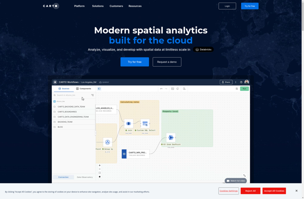
CartoDB
CartoDB is an open source platform for building location intelligence applications. It provides capabilities for spatial data storage, visualization, analysis, and publishing. Key features include:User-friendly drag and drop interface for creating interactive maps and dashboardsVisualization of geospatial datasets such as points, lines, and polygonsOptions for customizing maps with different basemaps,...
TransforMap
TransforMap is a free, open-source mind mapping and brainstorming software. It allows users to visually organize ideas, tasks, projects, and other information with the flexibility of a mind map interface.With TransforMap, users can:Create branching mind maps to break down large concepts and projects into an organized structureConnect related topics, ideas,...

Planet Labs
Planet Labs is an earth imaging company founded in 2010 and based in San Francisco, California. They operate the world's largest commercial satellite constellation with over 200 satellites in orbit, collecting imagery of the entire land mass of the Earth every day.Their high revisit rate and global coverage allows them...

Universal Maps Downloader
Universal Maps Downloader is a free and open source software application that provides the ability to download map images from various popular online map services, including Google Maps, Bing Maps, OpenStreetMap, MapQuest, Yandex Maps, and more.Some key features of Universal Maps Downloader:Supports downloading map images at various zoom levels ranging...

TomTom MyDrive
TomTom MyDrive is a free desktop and mobile app that interfaces with TomTom GPS navigation devices to provide expanded features and functionality. With MyDrive, users can plan routes and destinations on their computer, tablet, or phone and seamlessly send that information to their TomTom device.Key features of TomTom MyDrive include:Updated...

Mapline
Mapline is an open-source, self-hosted web application that allows users to create custom maps for free. It is an alternative to proprietary services like Google My Maps.Some key features of Mapline include:Ability to add markers, lines, shapes, and text notes to your mapsSupport for multiple layers on a single mapOptions...

GPS Navigator with Offline Maps
GPS Navigator is a feature-rich navigation and maps app for Android and iOS that is focused on providing accurate turn-by-turn directions even when offline. It sets itself apart by offering free offline map downloads for over 200 countries and territories worldwide, meaning you can navigate unfamiliar areas without racking up...

Google Maps Go
Google Maps Go is a streamlined version of the Google Maps app designed for Android Go edition devices. Android Go edition is a configuration of Android optimized for devices with less than 2GB of RAM, aimed at improving performance and accessibility in emerging markets.Some key features of Google Maps Go...
Mappy
Mappy is an online and mobile map service mainly focused on Europe. It provides detailed street-level maps for over 40 European countries, covering popular travel destinations like France, Germany, Italy, Spain, and the UK as well as smaller countries across the region.Key features of Mappy include:Interactive maps with zoom, pan,...