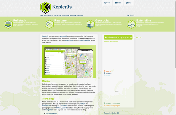
KeplerJs is an open-source web application framework for Node.js focused on scalability and high performance. It uses an architecture optimized for asynchronous request handling, making it well-suited for real-time web applications and APIs.
KeplerJs is an open-source web application framework for Node.js focused on scalability and high performance, optimized for asynchronous request handling.
What is KeplerJs?
KeplerJs is an open-source web application framework for Node.js focused on scalability and high performance. It uses an asynchronous, non-blocking architecture optimized for handling a high volume of concurrent requests with low latency.
Some key features of KeplerJs include:
Built-in support for horizontal scaling across multiple CPU cores/servers
First-class support for real-time features like WebSockets and Server-Sent Events
Middleware-based pipeline architecture for modular and reusable code
SQL and NoSQL database integrations
Template rendering support with EJS, Pug, Handlebars etc.
Session management and authentication helpers
Static file serving and compression
Robust ecosystem of third-party modules
KeplerJs shines for building modern, scalable HTTP APIs and real-time web applications. Its event-driven architecture makes it very efficient for I/O intensive web workloads. It's a good fit for building chat platforms, streaming analytics dashboards, real-time tracking/monitoring systems, and other high-throughput web services.
KeplerJs Features
Features
Built on top of Node.js and Express
Uses an asynchronous, non-blocking architecture
Supports horizontal scaling across multiple processes
Middleware and routing system for app organization
Google Maps is a web mapping platform and consumer application offered by Google. It offers satellite imagery, aerial photography, street maps, 360° interactive panoramic views of streets, real-time traffic conditions, and route planning for traveling by foot, car, bicycle and air, or public transportation.Key features of Google Maps include:Interactive street...
What Is MAPS.ME?MAPS.ME is a mobile maps and navigation app that provides detailed offline maps for over 200 countries. Originally open source, it was one of the first apps to make OpenStreetMap data accessible on mobile with a polished interface.Key FeaturesUsers download maps by country or region for fully offline...
OsmAnd (OpenStreetMap Automated Navigation Directions) is a free and open-source mobile map and navigation application developed for Android and iOS devices. It relies entirely on detailed, community-driven maps from the OpenStreetMap project and allows accessing them offline without an internet connection.Some of the key features and capabilities of OsmAnd include:Turn-by-turn...
OpenStreetMap (OSM) is a collaborative project to create a free and editable map of the world. Unlike proprietary map data from companies like Google or Apple, OSM map data is open and licensed under the Open Database License (ODbL), which allows anyone to use, modify, and distribute the data freely.The...
HERE WeGo is a free map and navigation app developed by HERE Technologies for iOS and Android devices. It allows users to navigate by car, public transportation, foot or bike using turn-by-turn voice guided directions. Key features of HERE WeGo include:Offline maps - Download maps to your device so you...
What Is Organic Maps?Organic Maps is a free, open-source maps and navigation app for Android and iOS. It uses OpenStreetMap data and works entirely offline — no internet connection needed for navigation, search, or route planning.Key FeaturesThe app provides turn-by-turn navigation for driving, cycling, and walking with voice guidance. Maps...
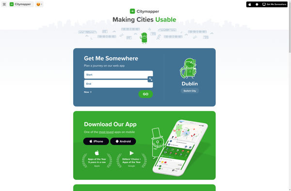
Citymapper is a mobile app and website that provides public transit information and directions for major cities around the world. First launched in 2011 for London's complex transit system, Citymapper has since expanded to over 80 cities globally.The app shows users comprehensive transit options combining subway, bus, rail, ferry, bike...
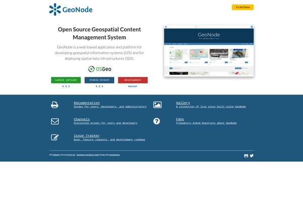
GeoNode is a free and open source platform built with Django that facilitates the creation, sharing, and collaborative use of geospatial data. It provides a standardized way to publish spatial datasets and metadata, allowing researchers, organizations, and citizens to easily share maps, data, and stories online.Some key features of GeoNode...
2GIS is a popular free map, local search and business directory mobile app and website operating in over 1800 cities across Russia, CIS, Europe, Asia and other countries. It offers detailed interactive maps, local business listings, navigation, reviews and other local information.Some key features of 2GIS include:Detailed vector maps for...
Transportr is an open-source public transportation app for Android devices. It is designed to help users search, plan, and navigate public transit systems in cities around the world.Some key features of Transportr include:Intuitive user interface for searching routes, planning trips, and viewing schedules and maps.Support for public transit systems in...
OpenMaps is an open source web mapping platform built on top of OpenStreetMap data. It allows users to create custom maps by drawing on top of existing maps and adding their own annotations, text labels, and lines/shapes. These custom maps can then be exported, embedded on websites, or shared publicly...