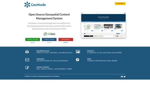
GeoNode is an open source platform for sharing geospatial data and maps. It enables organizations and individuals to easily publish, share, find, visualize and download geospatial information. GeoNode makes it easy to build spatial data infrastructures and web mapping application
GeoNode is an open source platform for sharing geospatial data and maps. It enables organizations and individuals to easily publish, share, find, visualize and download geospatial information. GeoNode makes it easy to build spatial data infrastructures and web mapping applications.
What is GeoNode?
GeoNode is a free and open source platform built with Django that facilitates the creation, sharing, and collaborative use of geospatial data. It provides a standardized way to publish spatial datasets and metadata, allowing researchers, organizations, and citizens to easily share maps, data, and stories online.
Some key features of GeoNode include:
An interactive map composer to create powerful web maps.
Drag and drop file uploading and management of spatial data files like GeoTIFFs, shapefiles, KML files.
Standardized metadata editing tools and cataloging for spatial datasets.
Social collaboration features such as comments, ratings, activity streams.
Groups for managing permissions and sharing private maps and data.
Built in search, APIs, and data harvesting tools to facilitate spatial data infrastructure.
Support for standards like CSW, WMS, WFS, WPS for interoperability with other systems.
With its user-friendly tools and robust spatial data management capabilities, GeoNode helps organizations engage citizens through interactive maps, dashboards and storytelling. It provides the building blocks for spatial data infrastructure projects. GeoNode has an active global developer/user community in fields like environmental protection, sustainable development, territorial planning, and humanitarian work.
GeoNode Features
Features
Cataloguing and search of geospatial data
Interactive web maps
Sharing and visualization of geospatial information
Collaboration tools
Role-based access control
Pricing
Open Source
Free
Pros
Open source and free
Large user community and active development
Supports many standard geospatial formats and services
Integrates with many other open source tools
Good documentation and tutorials available
Cons
Can be complex to install and configure
Limited customization and branding options
Not as full-featured as some commercial alternatives
Requires technical expertise to manage and develop
QGIS is a professional open-source Geographic Information System (GIS) software for working with maps and geospatial data. It is licensed under the GNU Public License. QGIS allows you to view, edit, analyze, process, and visualize spatial data in various formats including shapefiles, GeoTIFFs, PostGIS, SpatiaLite, GPX, and more. It supports...
Mapbox Studio is a powerful desktop application for designing custom map styles. It provides a graphical user interface that allows you to visually style vector tiles created with Mapbox tools and services.Some key features of Mapbox Studio include:Import vector tilesets created with Mapbox tools like Mapbox Streets and SatelliteStyle map...
SAGA GIS (System for Automated Geoscientific Analyses) is a free and open source geographic information system (GIS) software used for editing and analyzing spatial data. It contains a large set of geoscientific analysis functions and utilities for managing vector, raster and table data.Some key features of SAGA GIS include:Support for...
Mapotic is an open-source, self-hosted alternative to Mapbox that provides developers and designers with tools for creating interactive maps. Some key features of Mapotic include:Ability to design custom base maps with Mapnik and CartoCSSSupport for overlaying vector and raster map tiles from various sourcesTools for visualizing, analyzing, and processing geospatial...
Felt is an open-source web-based application for kanban-style project management and task tracking. It provides a visual interface for organizing tasks into pipelines represented as boards, lists, and cards.Some key features of Felt include:Boards to organize projects and track progress across different stagesCustom lists within each board to categorize tasks...
what3words is a geocoding system that has divided the world into 3 meter squares and assigned each square a unique 3 word identifier. For example, the square that contains the front door of 10 Downing Street in London has been assigned the 3 word address ///slurs.this.shark.This system allows people to...
Mapnik is an open-source toolkit for developing mapping applications. It provides the functionality to take spatial data inputs, apply cartographic styling rules and symbolization, and render high-quality maps.Some key features and capabilities of Mapnik include:Access to many common spatial data formats such as shapefiles, PostGIS, SQLite, GeoJSON, KML, and others.Flexible...
Mapserver is an open source geographic data rendering engine written in C. It allows users to publish spatial data and build interactive web mapping applications without the need for desktop GIS software. Mapserver excels at rendering spatial data and creating high-performance interactive maps that can be accessed via web browsers.Some...
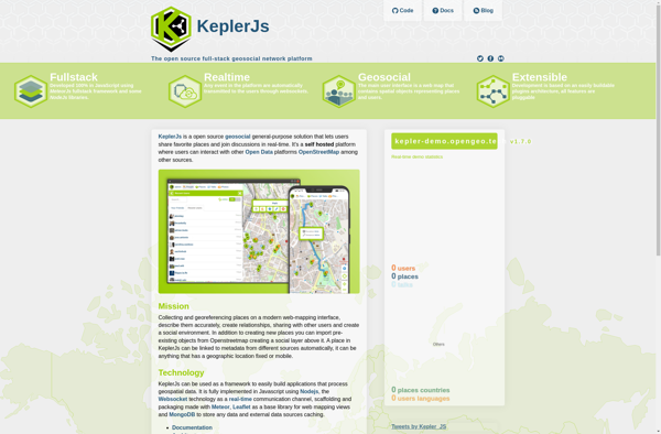
KeplerJs is an open-source web application framework for Node.js focused on scalability and high performance. It uses an asynchronous, non-blocking architecture optimized for handling a high volume of concurrent requests with low latency.Some key features of KeplerJs include:Built-in support for horizontal scaling across multiple CPU cores/serversFirst-class support for real-time features...
GeniusGIS is an open-source geographic information system (GIS) software application used for creating, editing, visualizing, analyzing and publishing geospatial data. It provides a user-friendly interface and powerful tools for working with maps and geographic information.Some key features of GeniusGIS include:Interactive map creation and editingAdvanced geospatial analysis and modeling toolsSupport for...
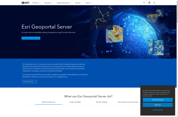
ESRI Geoportal Server is an open source software application used to stand up geospatial clearinghouse portals for managing and discovering metadata and associated geospatial resources. It provides a standards-based metadata catalog that allows users to publish, search, and access geospatial resources such as datasets, rasters, and web services.Key features of...
GeoSHAPE is an open-source geographic information system (GIS) software application used for working with maps and geographic information. It enables users to view, create, edit, analyze, and publish geospatial data. Key features of GeoSHAPE include:Interactive mapping with support for various map projections and coordinate systemsPowerful geospatial data editing tools for...