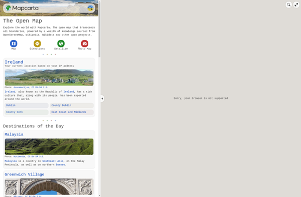
Mapcarta is an interactive map service that allows users to explore locations around the world. It provides detailed maps and information for cities, countries, and regions. Mapcarta maps can be embedded or shared easily.
Mapcarta is an interactive map service that allows users to explore locations around the world. It provides detailed maps and information for cities, countries, and regions. Mapcarta maps can be embedded or shared easily.
What is Mapcarta?
Mapcarta is an interactive online map service launched in 2009 that allows users to explore locations, cities, countries, and regions around the world. It provides detailed zoomable maps along with essential information and statistics about the places mapped. Some key features of Mapcarta include:
Zoomable maps covering the entire world down to street level detail
Information panels with facts, figures, photos, and links for each location
Mapping overlays like weather and traffic
Integration with Wikipedia for background details on locations
Custom branded maps that can be embedded into websites and shared easily
Support for multiple languages
Mapcarta offers an intuitive way to browse the world map,discover places in detail, and learn about different cities, countries and continents. Both website users and developers can leverage its maps and data to enhance applications, websites or explore areas that interest them.
Mapcarta Features
Features
Interactive maps with zoom and pan capabilities
Detailed maps for cities, countries and regions worldwide
Ability to search for and explore locations
Information cards for places with photos, descriptions and links
Customizable maps and embeds
Shareable map links
Available in multiple languages
Pricing
Freemium
Pros
Free to use with no signup required
Intuitive, user-friendly interface
High quality map graphics and data
Comprehensive global coverage
Easily embeddable and shareable
Frequent updates with new locations and data
Cons
Limited customization options compared to paid mapping platforms
No advanced features like directions, traffic data or custom layers
Lower level of detail than Google Maps in some areas
Lacks street view and indoor mapping capabilities
Primarily focused on exploration rather than navigation
Google Maps is a web mapping platform and consumer application offered by Google. It offers satellite imagery, aerial photography, street maps, 360° interactive panoramic views of streets, real-time traffic conditions, and route planning for traveling by foot, car, bicycle and air, or public transportation.Key features of Google Maps include:Interactive street...
What Is MAPS.ME?MAPS.ME is a mobile maps and navigation app that provides detailed offline maps for over 200 countries. Originally open source, it was one of the first apps to make OpenStreetMap data accessible on mobile with a polished interface.Key FeaturesUsers download maps by country or region for fully offline...
OpenStreetMap (OSM) is a collaborative project to create a free and editable map of the world. Unlike proprietary map data from companies like Google or Apple, OSM map data is open and licensed under the Open Database License (ODbL), which allows anyone to use, modify, and distribute the data freely.The...
HERE WeGo is a free map and navigation app developed by HERE Technologies for iOS and Android devices. It allows users to navigate by car, public transportation, foot or bike using turn-by-turn voice guided directions. Key features of HERE WeGo include:Offline maps - Download maps to your device so you...
Yandex Maps is a free online map service developed by Yandex, a Russian multinational technology company specializing in Internet-related services and products. Yandex Maps offers highly detailed and searchable maps, turn-by-turn navigation, public transit information, traffic data, and 360-degree panoramic street view images for over 220 countries around the world.The...
Guru Maps is an online mind mapping and brainstorming application designed to help users organize ideas and information visually. As an intuitive tool for project planning, brainstorming sessions, and task management, Guru Maps enables users to create colorful nonlinear maps to connect ideas, notes, files, links, and more.Key features of...
Qwant Maps is an open-source web mapping service developed by the French company Qwant aimed at providing privacy and protecting user data. Launched in 2019, Qwant Maps does not track user searches or collect private information the way many other mapping services do.Some key features of Qwant Maps include:Search for...
2GIS is a popular free map, local search and business directory mobile app and website operating in over 1800 cities across Russia, CIS, Europe, Asia and other countries. It offers detailed interactive maps, local business listings, navigation, reviews and other local information.Some key features of 2GIS include:Detailed vector maps for...