Qwant Maps is a privacy-focused map service created by the French company Qwant. It allows users to search for destinations, get directions, and browse interactive maps without tracking users or collecting personal data.
A French map service providing private search functionality for destination lookup, navigation directions, and interactive maps without user tracking or personal data collection.
What is Qwant Maps?
Qwant Maps is an open-source web mapping service developed by the French company Qwant aimed at providing privacy and protecting user data. Launched in 2019, Qwant Maps does not track user searches or collect private information the way many other mapping services do.
Some key features of Qwant Maps include:
Search for locations, directions, local businesses
Interactive maps to pan, zoom, select layers like transit/biking
Privacy commitment to not track users or sell data
Options to disable cookies and browse anonymously
Powered by OpenStreetMap data instead of proprietary maps
Available on desktop browsers and mobile apps for iOS and Android
While the map does not have the same level of detail or options as Google or Apple Maps, Qwant Maps aims to provide a solid maps experience while making user privacy a priority. It does not store personalized maps data, IP addresses or search history, and strives to avoid targeted advertising and location tracking seen in many other popular mapping services.
Google Maps is a web mapping platform and consumer application offered by Google. It offers satellite imagery, aerial photography, street maps, 360° interactive panoramic views of streets, real-time traffic conditions, and route planning for traveling by foot, car, bicycle and air, or public transportation.Key features of Google Maps include:Interactive street...
What Is MAPS.ME?MAPS.ME is a mobile maps and navigation app that provides detailed offline maps for over 200 countries. Originally open source, it was one of the first apps to make OpenStreetMap data accessible on mobile with a polished interface.Key FeaturesUsers download maps by country or region for fully offline...
OpenStreetMap (OSM) is a collaborative project to create a free and editable map of the world. Unlike proprietary map data from companies like Google or Apple, OSM map data is open and licensed under the Open Database License (ODbL), which allows anyone to use, modify, and distribute the data freely.The...
HERE WeGo is a free map and navigation app developed by HERE Technologies for iOS and Android devices. It allows users to navigate by car, public transportation, foot or bike using turn-by-turn voice guided directions. Key features of HERE WeGo include:Offline maps - Download maps to your device so you...
Arcane Maps is a feature-rich yet easy-to-use fantasy map creation tool designed specifically for tabletop roleplaying games like Dungeons & Dragons. With an intuitive interface, users can quickly sketch out custom maps with a variety of terrains, landmarks, borders, text labels, and other cartography elements.The software provides numerous brush styles...
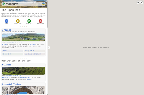
Mapcarta is an interactive online map service launched in 2009 that allows users to explore locations, cities, countries, and regions around the world. It provides detailed zoomable maps along with essential information and statistics about the places mapped. Some key features of Mapcarta include:Zoomable maps covering the entire world down...
Universal Maps Downloader is a free and open source software application that provides the ability to download map images from various popular online map services, including Google Maps, Bing Maps, OpenStreetMap, MapQuest, Yandex Maps, and more.Some key features of Universal Maps Downloader:Supports downloading map images at various zoom levels ranging...
Yandex Maps is a free online map service developed by Yandex, a Russian multinational technology company specializing in Internet-related services and products. Yandex Maps offers highly detailed and searchable maps, turn-by-turn navigation, public transit information, traffic data, and 360-degree panoramic street view images for over 220 countries around the world.The...
TomTom MyDrive is a free desktop and mobile app that interfaces with TomTom GPS navigation devices to provide expanded features and functionality. With MyDrive, users can plan routes and destinations on their computer, tablet, or phone and seamlessly send that information to their TomTom device.Key features of TomTom MyDrive include:Updated...
Guru Maps is an online mind mapping and brainstorming application designed to help users organize ideas and information visually. As an intuitive tool for project planning, brainstorming sessions, and task management, Guru Maps enables users to create colorful nonlinear maps to connect ideas, notes, files, links, and more.Key features of...
2GIS is a popular free map, local search and business directory mobile app and website operating in over 1800 cities across Russia, CIS, Europe, Asia and other countries. It offers detailed interactive maps, local business listings, navigation, reviews and other local information.Some key features of 2GIS include:Detailed vector maps for...
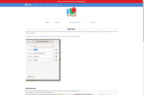
GNOME Maps is a mapping and navigation application built for the Linux GNOME desktop environment. Developed as part of the GNOME project, it is free and open source software.GNOME Maps allows users to view different map layers, including street maps, satellite imagery, and terrain. It has basic functionality like panning...
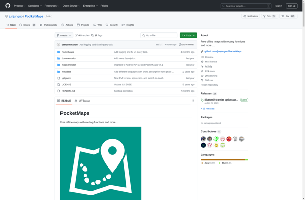
PocketMaps is an open source, offline GPS navigation app for Android devices. It allows users to download OpenStreetMap maps for offline use so navigation is possible without an internet connection. Some key features of PocketMaps include:Completely offline maps - no data connection needed once maps are downloadedTurn-by-turn voice guided GPS...
GPS Navigator is a feature-rich navigation and maps app for Android and iOS that is focused on providing accurate turn-by-turn directions even when offline. It sets itself apart by offering free offline map downloads for over 200 countries and territories worldwide, meaning you can navigate unfamiliar areas without racking up...
Acastus Photon is an open-source web application that serves as a self-hosted alternative to Pinterest. Like Pinterest, it allows users to create visual inspiration boards to collect, organize, and share images, links, notes, and other content.Some key features of Acastus Photon include:Creating public and private boards to organize contentFollowing other...
OffRoad OSM is an open source GPS navigation app designed specifically for off-road use. It works offline using downloaded OpenStreetMap maps so you can navigate trails and rural roads even without cell service or wifi.Some key features of OffRoad OSM include:Works completely offline for navigation in remote areasUses OpenStreetMap data...
Mappy is an online and mobile map service mainly focused on Europe. It provides detailed street-level maps for over 40 European countries, covering popular travel destinations like France, Germany, Italy, Spain, and the UK as well as smaller countries across the region.Key features of Mappy include:Interactive maps with zoom, pan,...
Doko Maps is an open-source, privacy-focused alternative to Google Maps. Developed by a non-profit organization, Doko Maps aims to provide an ethical mapping service that respects user privacy.Like Google Maps, Doko Maps offers features like turn-by-turn navigation for driving, walking, biking and public transit. It allows users to search for...