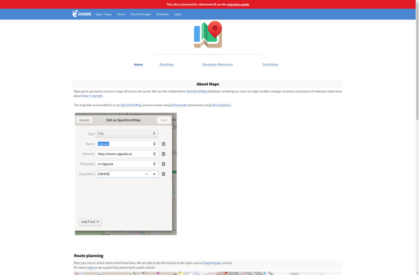
GNOME Maps is a free and open source map application for Linux, developed for the GNOME desktop environment. It offers basic map viewing and navigation features, including zooming, marker placement, and route planning.
A free and open source map application for Linux, offering basic map viewing and navigation features including zooming, marker placement, and route planning.
What is GNOME Maps?
GNOME Maps is a mapping and navigation application built for the Linux GNOME desktop environment. Developed as part of the GNOME project, it is free and open source software.
GNOME Maps allows users to view different map layers, including street maps, satellite imagery, and terrain. It has basic functionality like panning and zooming, geocode searching to find locations, as well as placing markers and planning routes from point A to point B.
Some key features of GNOME Maps include:
Interactive tile-based maps using data from OpenStreetMap and other providers
Worldwide coverage with access to street maps, satellite views and terrain
Search for locations by address, business name or coordinates
Smooth transitions between map types and zoom levels
Place pins, markers, shapes and lines onto maps
Get directions and routing between selected points
Save placed markers and routes for future reference
As an open source app, GNOME Maps is completely free to download and use. It works natively on Linux systems with the GNOME desktop environment. The focus is on providing an easy-to-use and functional maps and navigation application for GNOME desktop users.
GNOME Maps Features
Features
Displays OpenStreetMap maps
Allows searching for locations
Supports different map views like terrain and satellite
Provides driving, walking and cycling directions
Can bookmark locations
Integrates with GNOME desktop environment
Pricing
Free
Open Source
Pros
Free and open source
Clean and simple interface
Good integration with GNOME
Active development and updates
Cons
Limited features compared to proprietary alternatives
Google Maps is a web mapping platform and consumer application offered by Google. It offers satellite imagery, aerial photography, street maps, 360° interactive panoramic views of streets, real-time traffic conditions, and route planning for traveling by foot, car, bicycle and air, or public transportation.Key features of Google Maps include:Interactive street...
Google Earth is a geobrowser that accesses satellite and aerial imagery, ocean bathymetry, and other geographic data over the internet to represent the Earth as a three-dimensional globe. It was originally developed by Keyhole, Inc., a company acquired by Google in 2004.Google Earth allows users to search for addresses and...
OsmAnd (OpenStreetMap Automated Navigation Directions) is a free and open-source mobile map and navigation application developed for Android and iOS devices. It relies entirely on detailed, community-driven maps from the OpenStreetMap project and allows accessing them offline without an internet connection.Some of the key features and capabilities of OsmAnd include:Turn-by-turn...
What Is Organic Maps?Organic Maps is a free, open-source maps and navigation app for Android and iOS. It uses OpenStreetMap data and works entirely offline — no internet connection needed for navigation, search, or route planning.Key FeaturesThe app provides turn-by-turn navigation for driving, cycling, and walking with voice guidance. Maps...
MapQuest is a free online mapping service launched in 1996 that provides users with driving directions, traffic conditions, route planning, and interactive maps. It was one of the first and most popular online mapping sites before the rise of Google Maps and Bing Maps.Key features of MapQuest include:Driving directions for...
Marble is a free and open source note taking application designed specifically for Linux desktop environments like KDE Plasma and GNOME. It provides a simple yet effective way to create rich text notes, tackle checklists, set reminders, and organize your notes into notebooks.Some of the key features of Marble include:Rich...
Yandex Maps is a free online map service developed by Yandex, a Russian multinational technology company specializing in Internet-related services and products. Yandex Maps offers highly detailed and searchable maps, turn-by-turn navigation, public transit information, traffic data, and 360-degree panoramic street view images for over 220 countries around the world.The...
Qwant Maps is an open-source web mapping service developed by the French company Qwant aimed at providing privacy and protecting user data. Launched in 2019, Qwant Maps does not track user searches or collect private information the way many other mapping services do.Some key features of Qwant Maps include:Search for...
Transportr is an open-source public transportation app for Android devices. It is designed to help users search, plan, and navigate public transit systems in cities around the world.Some key features of Transportr include:Intuitive user interface for searching routes, planning trips, and viewing schedules and maps.Support for public transit systems in...
OffRoad OSM is an open source GPS navigation app designed specifically for off-road use. It works offline using downloaded OpenStreetMap maps so you can navigate trails and rural roads even without cell service or wifi.Some key features of OffRoad OSM include:Works completely offline for navigation in remote areasUses OpenStreetMap data...