eyeMaps is a mind mapping and brainstorming software that allows users to visually organize ideas and concepts. It has an intuitive drag-and-drop interface to easily create mind maps with topics, subtopics, notes, attachments and more.
eyeMaps is a mind mapping and brainstorming software that allows users to visually organize ideas and concepts. It has an intuitive drag-and-drop interface to easily create mind maps with topics, subtopics, notes, attachments and more.
What is EyeMaps?
eyeMaps is a feature-rich mind mapping and brainstorming software used by individuals and teams to visually organize ideas and concepts. It provides an intuitive drag-and-drop interface that allows users to easily create mind maps that include topics, subtopics, notes, attachments, task lists and more.
With eyeMaps, users can brainstorm ideas, plan projects, outline books and presentations, study and memorize information and more. Some key features include:
Intuitive interface for easily creating and organizing mind maps
Hierarchical topics and subtopics to break down concepts
Notes, links and file attachments to add details
Task lists for project planning
Context tabs to group and categorize information
Import/export options to share mind maps
Mind map presentation mode
Desktop and mobile apps
eyeMaps includes powerful customization options to tailor mind maps to specific needs. Users can add color themes, icons, images and visual cues. Templates help users get started for different use cases.
With its user-friendly interface, variety of features and customization options for both personal and professional use, eyeMaps is considered one of the top mind mapping solutions available.
EyeMaps Features
Features
Mind mapping and brainstorming software
Intuitive drag-and-drop interface
Create mind maps with topics, subtopics, notes, attachments
Google Maps is a web mapping platform and consumer application offered by Google. It offers satellite imagery, aerial photography, street maps, 360° interactive panoramic views of streets, real-time traffic conditions, and route planning for traveling by foot, car, bicycle and air, or public transportation.Key features of Google Maps include:Interactive street...
Google Earth is a geobrowser that accesses satellite and aerial imagery, ocean bathymetry, and other geographic data over the internet to represent the Earth as a three-dimensional globe. It was originally developed by Keyhole, Inc., a company acquired by Google in 2004.Google Earth allows users to search for addresses and...
OpenStreetMap (OSM) is a collaborative project to create a free and editable map of the world. Unlike proprietary map data from companies like Google or Apple, OSM map data is open and licensed under the Open Database License (ODbL), which allows anyone to use, modify, and distribute the data freely.The...
Bing Maps 3D is a 3D mapping platform from Microsoft that provides interactive maps and location intelligence services. It is part of the Bing Maps product suite.Some key features of Bing Maps 3D include:Interactive 3D map views with support for aerial, road, and hybrid map stylesAbility to incorporate 3D maps...
Apple Maps is a web mapping service developed by Apple Inc. It was introduced in 2012 with iOS 6 as a replacement for Google Maps on Apple devices. Apple Maps offers turn-by-turn navigation, interactive panoramic street views, Flyover mode for photorealistic 3D views of certain cities, support for transit routing...
TomTom MyDrive is a free desktop and mobile app that interfaces with TomTom GPS navigation devices to provide expanded features and functionality. With MyDrive, users can plan routes and destinations on their computer, tablet, or phone and seamlessly send that information to their TomTom device.Key features of TomTom MyDrive include:Updated...
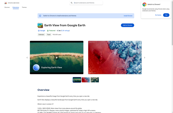
Earth View from Google Earth is a free browser extension available for Chrome, Firefox, and Edge that changes your new tab page to showcase gorgeous satellite photos of places around the world sourced from Google Earth. When you open a new tab, you'll be greeted with a breathtaking high resolution...
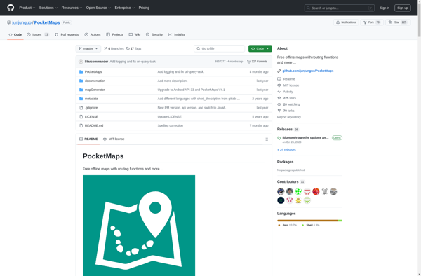
PocketMaps is an open source, offline GPS navigation app for Android devices. It allows users to download OpenStreetMap maps for offline use so navigation is possible without an internet connection. Some key features of PocketMaps include:Completely offline maps - no data connection needed once maps are downloadedTurn-by-turn voice guided GPS...
Hyperlapse Map is a mobile app that makes time-lapse videography simple and accessible. It utilizes a phone's camera and GPS to capture timelapses that can be mapped to the route traveled.To use the app, you simply open it and press record as you walk, drive, or move along any path....
GPS Navigator is a feature-rich navigation and maps app for Android and iOS that is focused on providing accurate turn-by-turn directions even when offline. It sets itself apart by offering free offline map downloads for over 200 countries and territories worldwide, meaning you can navigate unfamiliar areas without racking up...