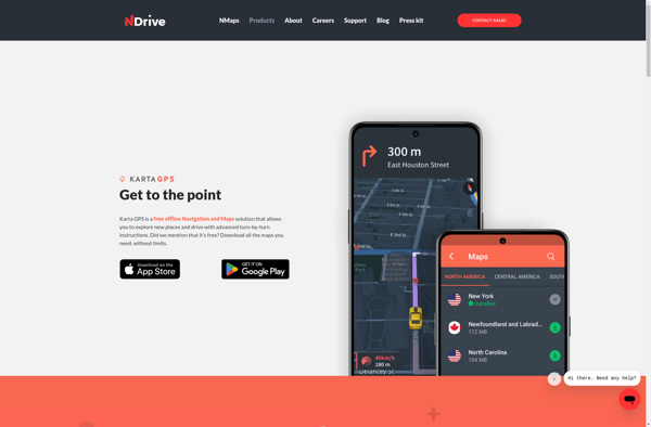
Karta GPS is a navigation and map app for hiking, cycling, and outdoor recreation. It provides topographic maps, route planning, tracking, and easy sharing. Karta is designed for offline use and works without data or cell service.
Karta GPS is a navigation and map app for hiking, cycling, and outdoor recreation. It provides topographic maps, route planning, tracking, and easy sharing. Karta is designed for offline use and works without data or cell service.
What is Karta GPS?
Karta GPS is a mapping, navigation, and GPS tracking app designed specifically for outdoor adventures like hiking, backpacking, cycling, and more. It provides topographic and terrain maps that work offline so you can navigate trails and rural areas without cell service.
Some key features of Karta GPS include:
Detailed topographic maps with trail and terrain data
Offline maps - download maps for use without data/cell service
Track recording and live GPS tracking
Interactive routing and trip planning tools
Location sharing to send trip details to friends/family
Landscape-oriented interface optimized for outdoor use
Supports most GPS, smartphone, and smartwatch devices
Karta is an ideal app for hikers, backpackers, trail runners, cyclists, and anyone venturing into rural areas beyond cell coverage. It provides confidence for navigating new locations by putting detailed GPS maps right in your pocket. The intuitive interface makes Karta easy to master while still offering powerful features for seasoned outdoorsmen.
Google Maps is a web mapping platform and consumer application offered by Google. It offers satellite imagery, aerial photography, street maps, 360° interactive panoramic views of streets, real-time traffic conditions, and route planning for traveling by foot, car, bicycle and air, or public transportation.Key features of Google Maps include:Interactive street...
Waze is a crowd-sourced GPS navigation and traffic app launched in 2008. It provides turn-by-turn navigation along with real-time traffic updates, road hazard reports, and user-submitted edits of roads and addresses.Key features of Waze include:Real-time traffic updates - Users can report accidents, traffic jams, police traps, etc. to alert other...
What Is MAPS.ME?MAPS.ME is a mobile maps and navigation app that provides detailed offline maps for over 200 countries. Originally open source, it was one of the first apps to make OpenStreetMap data accessible on mobile with a polished interface.Key FeaturesUsers download maps by country or region for fully offline...
OsmAnd (OpenStreetMap Automated Navigation Directions) is a free and open-source mobile map and navigation application developed for Android and iOS devices. It relies entirely on detailed, community-driven maps from the OpenStreetMap project and allows accessing them offline without an internet connection.Some of the key features and capabilities of OsmAnd include:Turn-by-turn...
HERE WeGo is a free map and navigation app developed by HERE Technologies for iOS and Android devices. It allows users to navigate by car, public transportation, foot or bike using turn-by-turn voice guided directions. Key features of HERE WeGo include:Offline maps - Download maps to your device so you...
What Is Organic Maps?Organic Maps is a free, open-source maps and navigation app for Android and iOS. It uses OpenStreetMap data and works entirely offline — no internet connection needed for navigation, search, or route planning.Key FeaturesThe app provides turn-by-turn navigation for driving, cycling, and walking with voice guidance. Maps...
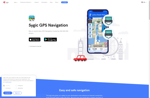
Sygic GPS Navigation is a popular offline navigation application for Android and iOS devices. It allows users to navigate anywhere in the world without needing an internet or data connection. Some key features of Sygic include:Detailed maps of Europe, North America, Australia, Brazil, and other regions that are optimized for...
Apple Maps is a web mapping service developed by Apple Inc. It was introduced in 2012 with iOS 6 as a replacement for Google Maps on Apple devices. Apple Maps offers turn-by-turn navigation, interactive panoramic street views, Flyover mode for photorealistic 3D views of certain cities, support for transit routing...
2GIS is a popular free map, local search and business directory mobile app and website operating in over 1800 cities across Russia, CIS, Europe, Asia and other countries. It offers detailed interactive maps, local business listings, navigation, reviews and other local information.Some key features of 2GIS include:Detailed vector maps for...
Magic Earth is an open-source, free mobile map application developed for Android and iOS devices. It can be used as a fully-functional GPS navigation software both online and offline. Some of the key features include:Downloads offline vector maps worldwide for using the app without internet connection.Supports turn-by-turn voice navigation and...
Galileo Offline Maps is a free and open-source offline maps application developed by Galileo Developers Community. It allows users to download OpenStreetMap maps for offline use and access them later without an internet connection. The application works across Windows, macOS, Linux, Android and iOS platforms.Some key features of Galileo Offline...
iTajPlus is a comprehensive software program designed to assist with Quran memorization, learning and review. It includes features such as:High quality audio recitation of the entire Quran with multiple reciters to choose fromVerse-by-verse text and audio highlighting that follows along as verses are recitedMemorization tools like flashcards, quizzes and tracking...