Mobile Trail Explorer

Mobile Trail Explorer

Mobile Trail Explorer is a mobile app that allows hikers, backpackers, and other outdoor enthusiasts to easily find and explore trails. The app provides detailed trail maps, navigation tools, weather information, and community reviews to help users plan trips and stay safe on the
Mobile Trail Explorer image
hiking navigation trails maps weather trip-planning outdoors

Mobile Trail Explorer: Find & Explore Trails

Mobile Trail Explorer is a mobile app that allows hikers, backpackers, and other outdoor enthusiasts to easily find and explore trails. The app provides detailed trail maps, navigation tools, weather information, and community reviews to help users plan trips and stay safe on the trails.

What is Mobile Trail Explorer?

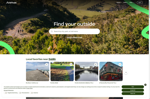
Mobile Trail Explorer is a popular mobile app designed specifically for hikers, backpackers, trail runners, mountain bikers, and other outdoor adventure seekers. The app allows users to easily discover new trails based on location, difficulty, distance, amenities, and other parameters.

Once a trail is selected, Mobile Trail Explorer provides a wealth of information to help users plan their trip. Detailed interactive maps illustrate the trail path, intersection with other trails, elevation profile, and points of interest. Turn-by-turn voice guided navigation helps ensure users stay on track during their hike. Up-to-date weather reports and forecasts keep users prepared for the conditions. Community reviews, photos, and tips provide insider knowledge from fellow adventurers.

During the hike, Mobile Trail Explorer lets users track their progress with GPS tracking. Useful tools like a step counter, speedometer, altitude monitor, and compass transform a smartphone into a powerful trail gadget. Along the way, users can log field notes, record geo-tagged photos, mark waypoints, and more. After the hike, favorite trails can be saved for future reference and shared across social media.

With an intuitive interface optimized for use offline and intelligent features tailored specifically for hikers, Mobile Trail Explorer makes venturing into the outdoors more accessible and enjoyable. The app aims to inspire appreciation for nature, promote safe and responsible recreation, and build a community around outdoor trails.

Mobile Trail Explorer Features

Features

  1. Detailed trail maps
  2. Turn-by-turn navigation
  3. Trail difficulty ratings
  4. Points of interest
  5. Weather forecasts
  6. Community reviews
  7. Offline access
  8. Route recording
  9. Photo sharing

Pricing

  • Freemium

Pros

Helps find new trails to explore

Provides navigation on the trail

Lets you view trail details and reviews

Can access maps and data offline

Records and shares your hiking routes

Free to download and use

Cons

Limited number of trails in database

Voice navigation not available

Requires cell/data connection for some features

May drain phone battery quickly


The Best Mobile Trail Explorer Alternatives

Top Travel & Location and Outdoor Recreation and other similar apps like Mobile Trail Explorer


Locus Map icon

Locus Map

Locus Map is a feature-rich GPS navigation and tracking app designed specifically for outdoor activities like hiking, geocaching, cycling, and more. It works offline for reliability and lets you download detailed topographic and cycling maps to navigate on the go when data connectivity is limited.Key features include:Offline topographic, cycling, and...
Locus Map image
ASICS Runkeeper icon

ASICS Runkeeper

ASICS Runkeeper is a fitness tracking and training app originally developed by FitnessKeeper Inc. before being acquired by ASICS in 2016. The app allows users to track various workouts including running, walking, cycling, hiking, cardio training and more using GPS and provides detailed statistics and analysis such as duration, distance,...
ASICS Runkeeper image
Sygic GPS Navigation icon

Sygic GPS Navigation

Sygic GPS Navigation is a popular offline navigation application for Android and iOS devices. It allows users to navigate anywhere in the world without needing an internet or data connection. Some key features of Sygic include:Detailed maps of Europe, North America, Australia, Brazil, and other regions that are optimized for...
Sygic GPS Navigation image
Charity Miles icon

Charity Miles

Charity Miles is a free app that allows users to raise money for charity when they walk, run, or bike. It works by tracking the user's physical activity, such as running or cycling, using the phone's GPS sensors. Corporate sponsors then donate money for each mile that the user moves.When...
Charity Miles image
 GraphHopper  icon

GraphHopper

GraphHopper is an open-source Java-based routing engine optimized for speed and memory efficiency. It uses road network data from OpenStreetMap to calculate the best route between locations for various modes of transportation including driving cars, riding bikes, walking, and more.Some key features of GraphHopper include:Fast routing calculations thanks to its...
 GraphHopper  image
Zombies, Run! icon

Zombies, Run!

Zombies, Run! is an immersive running app that turns your outdoor workouts into an interactive adventure. The app works by playing audio stories that adapt to changes in your running pace - making you feel like you're running away from zombies chasing you.In the game's plot, you are a runner...
Zombies, Run! image
BT747 icon

BT747

BT747 is a free, open source Bluetooth diagnostic utility and exploration tool for Windows. It enables users to scan for nearby Bluetooth devices, connect to them, browse services/characteristics, read & write values, and more.Some key features of BT747 include:Scanning and discovery of Bluetooth Low Energy (BLE) devicesConnecting and pairing with...
BT747 image
Runbit icon

Runbit

Runbit is an online project management and collaboration software designed for teams of all sizes. It provides a variety of features to help organize team projects, assign tasks, manage resources, track time, share files, communicate in real-time, generate reports, and more.Some of the key features of Runbit include:Intuitive task management...
Runbit image
TrainAsONE icon

TrainAsONE

TrainAsONE is an AI-powered fitness and workout tracking platform. It goes beyond traditional workout apps by providing fully customized training plans tailored to each user's specific goals, experience level, equipment access, and more.Some key features of TrainAsONE include:AI Coaching - An advanced algorithm analyzes your profile and fitness history to...
TrainAsONE image
EveryTrail icon

EveryTrail

EveryTrail is a popular GPS-based hiking, biking, and trail app that helps outdoor enthusiasts discover, record, and share their adventures on trails worldwide. With a database of over 300,000 mapped trails, EveryTrail allows users to find trails based on location, difficulty, length, scenery and more.Some key features of EveryTrail include:Comprehensive...
EveryTrail image
TrekBuddy icon

TrekBuddy

TrekBuddy is a versatile backpacking and hiking app that aids outdoor enthusiasts in planning and documenting their adventures in nature. Whether heading out for a long-distance thru hike, a multi-day loop, or just a quick overnight trip, TrekBuddy streamlines the process of organizing gear lists, dialing in routes, booking campsites,...
TrekBuddy image
BbTracker icon

BbTracker

bbTracker is an open-source issue/bug/feature tracking and project management tool. It is designed to be lightweight, easy to use, and provide more features than a simple todo list for small development teams.With bbTracker, you can:Track issues, bugs, features, tasks, stories, etc. for your software projectsAssign issues to team members with...
BbTracker image
TripTrack icon

TripTrack

TripTrack is an end-to-end travel and expense management solution designed specifically for mid-market businesses. It provides powerful yet easy-to-use capabilities to manage the entire lifecycle of business travel, from planning and booking to reimbursement.Key features of TripTrack include:Automated expense reports - Employees can easily capture expenses on the go via...
TripTrack image
Trails - GPS tracker icon

Trails - GPS tracker

Trails is a feature-rich GPS tracking app used for recording outdoor activities like hiking, running, cycling, and more. It provides detailed topographic maps that work offline, allowing users to navigate trails even without cell service.Some key features of Trails include:Recording routes, with real-time tracking showing your location on the mapMarking...
Trails - GPS tracker image