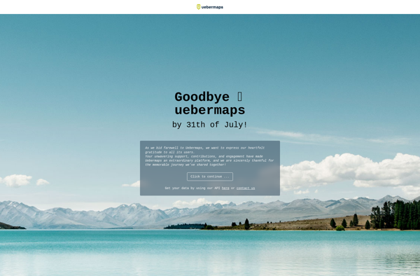
Uebermaps is an open-source, self-hosted web application for creating and sharing custom maps. It allows users to easily annotate locations on a map, add descriptions, photos, and custom icons. Useful for travelers, event organizers, and anyone wanting to create a customized map.
A self-hosted web application for creating and sharing custom maps with location annotations, descriptions, photos, and custom icons, ideal for travelers, event organizers, and map enthusiasts.
What is Uebermaps?
Uebermaps is an open-source web application that allows users to create fully customizable maps that can be shared online. It is self-hosted, meaning you download and install it on your own server or website.
Some key features of Uebermaps include:
Add custom markers, lines, polygons to a map
Annotate points of interest with descriptions, photos, and custom icons
Organize places into categories with different icons and colors
Allow visitors to search and filter map contents
Share your maps publicly or privately embed on websites
Works on mobile and desktop browsers
Open-source (MIT license) codebase that can be extended
Uebermaps is very flexible and enables creators to highlight locations relevant to them. For example, travelers can map out their journeys with places to stay and things to do. Event organizers can show venues and schedules. Urban planners can map city projects and developments.
The interface is intuitive enough for non-technical users. At the same time, developers can easily customize and extend Uebermaps since it is open-source software.
So if you need to make a custom map with points of interest, details, categories, photos, etc. and want to share it online, Uebermaps is an excellent free option to consider.
Uebermaps Features
Features
Create custom maps with markers, descriptions and photos
Google Maps is a web mapping platform and consumer application offered by Google. It offers satellite imagery, aerial photography, street maps, 360° interactive panoramic views of streets, real-time traffic conditions, and route planning for traveling by foot, car, bicycle and air, or public transportation.Key features of Google Maps include:Interactive street...
Google Earth is a geobrowser that accesses satellite and aerial imagery, ocean bathymetry, and other geographic data over the internet to represent the Earth as a three-dimensional globe. It was originally developed by Keyhole, Inc., a company acquired by Google in 2004.Google Earth allows users to search for addresses and...
OpenStreetMap (OSM) is a collaborative project to create a free and editable map of the world. Unlike proprietary map data from companies like Google or Apple, OSM map data is open and licensed under the Open Database License (ODbL), which allows anyone to use, modify, and distribute the data freely.The...
TripIt is a leading travel organization and planning app that aims to alleviate travel stress by organizing travel details all in one place. Users can forward booking confirmations from over hundreds of airlines, hotels, car rental companies and more to [email protected], and TripIt will automatically create an itinerary that syncs...
Mapbox Studio is a powerful desktop application for designing custom map styles. It provides a graphical user interface that allows you to visually style vector tiles created with Mapbox tools and services.Some key features of Mapbox Studio include:Import vector tilesets created with Mapbox tools like Mapbox Streets and SatelliteStyle map...
HERE WeGo is a free map and navigation app developed by HERE Technologies for iOS and Android devices. It allows users to navigate by car, public transportation, foot or bike using turn-by-turn voice guided directions. Key features of HERE WeGo include:Offline maps - Download maps to your device so you...
Yelp is a website and mobile app that hosts crowdsourced reviews about local businesses. It allows users to search for and find information about businesses such as restaurants, shopping, nightlife, services and more. Users can read and write reviews that detail their experiences at those businesses, give star ratings, upload...
Apple Maps is a web mapping service developed by Apple Inc. It was introduced in 2012 with iOS 6 as a replacement for Google Maps on Apple devices. Apple Maps offers turn-by-turn navigation, interactive panoramic street views, Flyover mode for photorealistic 3D views of certain cities, support for transit routing...
Leaflet is an open-source JavaScript library for building web mapping applications. Here is a more detailed overview:- Leaflet is designed with simplicity, performance and usability in mind. It offers easy integration with other mapping libraries and APIs.- The library is extremely lightweight at only about 38 KB, which allows for...
OpenMapTiles is an open-source project that provides software and data to self-host various mapping services and capabilities. Some of the key components and capabilities include:Vector and raster map tiles - OpenMapTiles provides scripts and data to generate your own map tile sets including OpenStreetMap data. This allows hosting them yourself...
Yandex Maps is a free online map service developed by Yandex, a Russian multinational technology company specializing in Internet-related services and products. Yandex Maps offers highly detailed and searchable maps, turn-by-turn navigation, public transit information, traffic data, and 360-degree panoramic street view images for over 220 countries around the world.The...
2GIS is a popular free map, local search and business directory mobile app and website operating in over 1800 cities across Russia, CIS, Europe, Asia and other countries. It offers detailed interactive maps, local business listings, navigation, reviews and other local information.Some key features of 2GIS include:Detailed vector maps for...