MapSphere
MapSphere is an open-source web mapping platform for creating custom interactive maps. It allows users to easily visualize data on customizable vector and raster maps.

MapSphere: Open-Source Web Mapping Platform
Create custom interactive maps with MapSphere, an open-source web mapping platform for visualizing data on customizable vector and raster maps.
What is MapSphere?
MapSphere is an open-source web mapping platform designed for creating custom interactive maps. It provides a user-friendly editor that allows users without GIS expertise to easily visualize various types of data on maps.
Key features of MapSphere include:
- Intuitive drag-and-drop editor for adding vector and raster data layers
- Custom base maps using WMS, TMS, XYZ tile services
- Styling and analysis tools for vector data
- Heatmaps, clusters, filters
- Support for GeoJSON, TopoJSON, KML, GPX, CSV formats
- Shareable fullscreen maps with navigation controls
- Extensive JavaScript API for advanced customization
- Mobile-friendly responsive design
With its ease of use, flexibility and focus on customization, MapSphere is a great option for organizations and developers looking to publish their geo-data online without investing in commercial mapping platforms.
MapSphere Features
Features
- Open-source web mapping platform
- Customizable vector and raster maps
- Interactive maps with popups and legends
- Support for various data formats like GeoJSON, KML, GPX
- Tile server for hosting map tiles
- Custom basemaps
- Marker clustering
- Heatmaps
- Routing and geocoding
- User management and access control
- Plugin architecture
Pricing
- Open Source
- Self-Hosted
Pros
Free and open source
Highly customizable
Support for advanced GIS functionality
Active community support
Self-hosted option available
Cons
Steep learning curve
Limited documentation
Not as user friendly as commercial alternatives
Requires technical expertise to setup and configure
Official Links
Reviews & Ratings
Login to ReviewThe Best MapSphere Alternatives
View all MapSphere alternatives with detailed comparison →
Top Travel & Location and Mapping and other similar apps like MapSphere
Here are some alternatives to MapSphere:
Suggest an alternative ❐Google Maps
Google Maps is a web mapping platform and consumer application offered by Google. It offers satellite imagery, aerial photography, street maps, 360° interactive panoramic views of streets, real-time traffic conditions, and route planning for traveling by foot, car, bicycle and air, or public transportation.Key features of Google Maps include:Interactive street...

Google Earth
Google Earth is a geobrowser that accesses satellite and aerial imagery, ocean bathymetry, and other geographic data over the internet to represent the Earth as a three-dimensional globe. It was originally developed by Keyhole, Inc., a company acquired by Google in 2004.Google Earth allows users to search for addresses and...

OpenStreetMap
OpenStreetMap (OSM) is a collaborative project to create a free and editable map of the world. Unlike proprietary map data from companies like Google or Apple, OSM map data is open and licensed under the Open Database License (ODbL), which allows anyone to use, modify, and distribute the data freely.The...

HERE WeGo
HERE WeGo is a free map and navigation app developed by HERE Technologies for iOS and Android devices. It allows users to navigate by car, public transportation, foot or bike using turn-by-turn voice guided directions. Key features of HERE WeGo include:Offline maps - Download maps to your device so you...

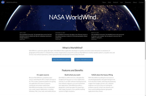
NASA World Wind
NASA World Wind is an open source, cross-platform virtual globe software that allows users to visualize the Earth and its terrain in 3D. Developed by NASA, it provides a detailed and interactive view of the planet using NASA satellite imagery and aerial photography.Key features of NASA World Wind include:Interactive 3D...
Apple Maps
Apple Maps is a web mapping service developed by Apple Inc. It was introduced in 2012 with iOS 6 as a replacement for Google Maps on Apple devices. Apple Maps offers turn-by-turn navigation, interactive panoramic street views, Flyover mode for photorealistic 3D views of certain cities, support for transit routing...

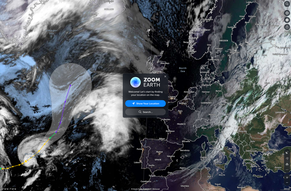
Zoom Earth
Zoom Earth is an interactive, real-time map of the planet that uses high-resolution satellite imagery and other geographical data to create a detailed and customizable view of locations around the world. Users can zoom in from space all the way to street level, tracking everything from weather systems to city...
Leaflet
Leaflet is an open-source JavaScript library for building web mapping applications. Here is a more detailed overview:- Leaflet is designed with simplicity, performance and usability in mind. It offers easy integration with other mapping libraries and APIs.- The library is extremely lightweight at only about 38 KB, which allows for...

Earth Browser
Earth Browser is an interactive 3D globe software program that provides a highly detailed visualization of planet Earth by integrating a wide range of geographic datasets. It enables users to explore the Earth's surface, oceans, atmosphere, and outer space in an immersive and customizable 3D environment.Key features of Earth Browser...

Marble
Marble is a free and open source note taking application designed specifically for Linux desktop environments like KDE Plasma and GNOME. It provides a simple yet effective way to create rich text notes, tackle checklists, set reminders, and organize your notes into notebooks.Some of the key features of Marble include:Rich...

Yandex Maps
Yandex Maps is a free online map service developed by Yandex, a Russian multinational technology company specializing in Internet-related services and products. Yandex Maps offers highly detailed and searchable maps, turn-by-turn navigation, public transit information, traffic data, and 360-degree panoramic street view images for over 220 countries around the world.The...

2GIS
2GIS is a popular free map, local search and business directory mobile app and website operating in over 1800 cities across Russia, CIS, Europe, Asia and other countries. It offers detailed interactive maps, local business listings, navigation, reviews and other local information.Some key features of 2GIS include:Detailed vector maps for...

Flash Earth
Flash Earth is a free, interactive 3D globe developed using Adobe Flash. It allows users to visually explore the Earth through high-resolution satellite imagery and aerial photography.Some key features of Flash Earth include:Seamless, zoomable maps from space down to street level3D terrain showing topological features like mountains and valleysOcean floor...

UMP-pcPL
UMP-pcPL is an open-source, cross-platform packet manipulation and traffic generation software designed for testing and benchmarking networks and devices. It provides a suite of tools that allow users to construct custom packets, replay traffic from packet captures, generate traffic and flows, and assess performance.Some key features of UMP-pcPL include:Constructing custom...

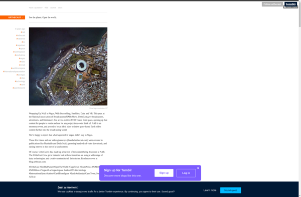
Urthecast
Urthecast is a Vancouver-based technology company that specializes in geospatial data and services by leveraging its network of Earth Observation (EO) sensors in space. The company provides imagery and data for a wide range of industries through its UrtheDaily, streaming video, and API services.Urthecast operates the world's first commercially-available, full-color...